
Delhi Metro Map : The Lifeline of the City
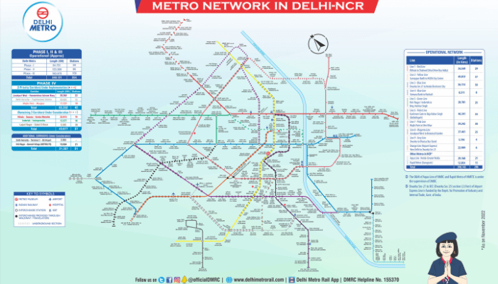
The Delhi Metro Map For millions of commuters, the Delhi Metro is more than just a transit system; it is the city’s very lifeline. The Delhi Metro map is arguably the most critical navigational tool for anyone looking to travel efficiently across the National Capital Region (NCR). This ever-expanding network connects far-flung corners of the city, from Gurugram to Noida and Ghaziabad, making it an indispensable asset for daily travelers and tourists alike. In 2023, the metro’s total passenger traffic impressively crossed the two billion mark, a testament to its importance.
Understanding this map is the first step to mastering travel in the capital. Understanding the Color-Coded Lines The genius of the Delhi Metro map lies in its simplicity. Each route is assigned a distinct color, which makes identifying your path incredibly straightforward. For instance, the Yellow Line connects North and South Delhi, while the Blue Line is the longest corridor, stretching from Dwarka in the west to Noida and Vaishali in the east. This color-coding system is a universal language, easily understood by locals and international visitors, eliminating confusion and making journey planning a breeze. The system currently features 10 color-coded lines, ensuring comprehensive coverage across the city.
Major lines include:
Red Line: One of the oldest lines, connecting Rithala to Shaheed Sthal.
Yellow Line: A crucial north-south corridor linking Samaypur Badli to Millennium City Centre (Gurugram).
Blue Line: The most extensive line, connecting Dwarka Sector 21 to Noida Electronic City and Vaishali.
Green Line: Connects major areas in West Delhi.
Violet Line: Runs from Kashmere Gate to Raja Nahar Singh in Ballabhgarh.
Airport Express (Orange) Line: Provides a swift connection from New Delhi Railway Station to the airport.
Pink Line: One of the longest lines, forming a ‘U’ shape along the Inner Ring Road.
Magenta Line: India’s first driverless metro line, connecting Janakpuri West to Botanical Garden.
Key Interchange Stations to Know While the color-coded lines simplify travel, the interchange stations are where the magic truly happens, allowing you to switch between lines seamlessly. Knowing these key hubs is vital for efficient travel. For example, Rajiv Chowk, located in the heart of Connaught Place, is one of the busiest interchanges, connecting the Yellow and Blue Lines. Another critical hub is Kashmere Gate, which is unique for connecting three lines: the Red, Yellow, and Violet Lines. Other significant interchanges include Central Secretariat (Yellow and Violet Lines), Mandi House (Blue and Violet Lines), and the Hauz Khas station, which connects the Yellow and Magenta lines. Planning your route around these stations can significantly cut down your travel time.
Using the Metro: Fares, Timings, and Smart Cards The Delhi Metro is not only efficient but also incredibly accessible. Services generally begin around 5:30 AM and run until 11:30 PM, with trains arriving every 2-3 minutes during peak hours. However, the Airport Express Line starts even earlier, at 4:45 AM. To travel, you have several options. You can buy single-journey tokens, but for convenience and cost savings, a Delhi Metro Smart Card is highly recommended. These cards offer a 10% discount on every journey. You can recharge them at any station or online through the DMRC website or digital wallets like Paytm. Recently, the DMRC also launched a ‘Multiple Journey QR Ticket’ facility through its mobile app, allowing your smartphone to function as a digital smart card. This removes the need to carry a physical card, further simplifying your travel experience.You can get the complete map on Delhi metro website.
Deconstructing the Megacity: The Delhi City Map
Delhi vs. New Delhi: Clearing the Confusion
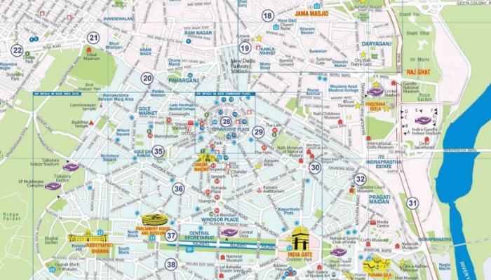
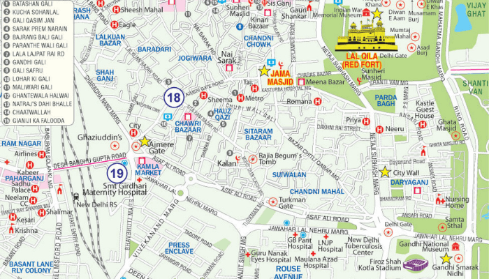
One of the first things a good new delhi india map clarifies is the distinction between “Delhi” and “New Delhi.” Many use the terms interchangeably, but they are geographically and historically distinct. New Delhi is the capital of India and an administrative district of Delhi. It was designed by British architects Edwin Lutyens and Herbert Baker in the early 20th century and is characterized by its wide, tree-lined boulevards and impressive government buildings. In contrast, Delhi (often referred to as Old Delhi or ‘Purani Dilli’) is a much older part of the city, with a history stretching back centuries. It is known for its narrow, winding lanes, bustling bazaars, and historic Mughal-era architecture. A city map clearly delineates these areas, helping you appreciate their unique characters.The 11 Districts of Delhi
The National Capital Territory (NCT) of Delhi is divided into 11 administrative districts. Understanding these can help you better navigate the city and locate specific areas. A detailed city map will show the boundaries of these districts, which include: Each district has its own unique identity and attractions. Therefore, using a district-level map can be incredibly helpful for localized exploration. You can find these detailed maps on various online platforms or through dedicated map applications.Hitting the Streets: A Guide to the Delhi Road Map
Major Arterial Roads and Highways
Several key roads form the backbone of Delhi’s road network. The most important of these are the Ring Road and the Outer Ring Road. These two circular arteries encircle the city and connect almost all major areas. Understanding their layout can provide a mental framework for navigating the entire city. Other critical routes include: A good road map will clearly display these major roads, helping you plan your journey and avoid getting lost in the maze of smaller streets.Navigating with Real-Time Traffic Apps
In a city like Delhi, a static paper map is often not enough. Real-time traffic conditions can change in an instant. This is where navigation apps like Google Maps and Waze become essential companions. These apps provide live traffic data, suggest the fastest routes, and offer turn-by-turn voice navigation. They can alert you to accidents, road closures, and heavy congestion, allowing you to choose an alternative path. Using a google delhi map on your smartphone is the smartest way to navigate the city’s roads, ensuring you reach your destination in the shortest possible time. These apps are constantly updated, providing a level of accuracy that a printed map simply cannot match.Conclusion
Frequently Asked Questions (FAQ)
What is the best map for tourists in Delhi?
For tourists, the best approach is to use a combination of maps. A dedicated tourist map is excellent for identifying key attractions and their locations. This should be used alongside a Delhi Metro map, as most tourist spots are well-connected by the metro. For real-time navigation and exploring areas off the beaten path, a digital tool like Google Maps is invaluable.How can I use the Delhi Metro map effectively?
To use the Delhi Metro map effectively, first identify your starting station and your destination. Note the color of the line for each. Then, find the shortest route, looking for the interchange station where you might need to switch lines. Key interchanges like Rajiv Chowk, Kashmere Gate, and Mandi House are crucial for connecting between different lines.Is Google Maps reliable in Delhi?
Yes, Google Maps is highly reliable in Delhi for road navigation. It provides real-time traffic updates, which are essential for avoiding congestion. It is also useful for finding locations, planning walking routes, and getting information on public transport, including bus and metro timings. It’s a must-have app for navigating the city.What is the difference between Delhi and New Delhi on a map?
On a map, New Delhi is shown as a specific, smaller area within the larger National Capital Territory of Delhi. New Delhi is the capital city and is characterized by its planned, grid-like layout and government buildings. Delhi refers to the entire territory, which includes the ancient city of Old Delhi, various other districts, and the satellite towns that form the NCR.How can I get a physical copy of a Delhi map?
Physical maps of Delhi, including tourist maps and metro maps, are widely available. You can often get them for free at the airport, major railway stations, hotels, and official tourist information centers. The Delhi Metro stations also have large, clear maps displayed and often provide pocket-sized versions.Table of Contents
Looking for Flights? Check Best Deals


Looking for hotels? Check Best Deals


Looking for Travel packages? Check Best Deals


Anita Rohilla
Anita Rohilla is a 28-year-old travel enthusiast and product tester with 5 years of experience reviewing travel gear and services. From backpacks to booking platforms, she tests and reviews each product to provide practical insights for travelers.

AI Assistant
Our AI writing assistant supports the creation of travel content under strict human supervision. All AI-generated posts are thoroughly reviewed, fact-checked, and updated by our team to maintain trust and accuracy in our travel recommendations.

Best Cafes in Delhi for Every Mood and Budget
If you’re looking for the best cafes in Delhi, you’re in for a treat. From hidden gems in quiet corners to lively spots with rooftop

Best Hotels in Delhi NCR for Every Budget
Looking for good hotels in Delhi NCR? Whether you’re visiting for business or a short trip, the region has a wide range of accommodations. From

Places to Visit in New Delhi: A Complete Travel Guide
New Delhi, the vibrant capital of India, is a city that blends history, culture, and modernity. From iconic landmarks to lush gardens and fascinating museums,