
Tourist Map of Bangalore: Your Gateway to the City's Wonders
Parks and Green Spaces: The Lungs of the City
Bangalore’s reputation as the Garden City is well-earned, and no visit is complete without immersing yourself in its verdant landscapes. A quality tourist map will prominently feature these natural havens. Lalbagh Botanical Garden is a must-visit, famous for its historic glasshouse, diverse plant species, and the annual flower shows that transform it into a riot of color. Another iconic green space is Cubbon Park, a sprawling oasis in the city’s heart, perfect for a leisurely stroll or a quiet morning amidst nature. These parks are not just recreational spots; they are a vital part of the city’s heritage and identity.Historical and Architectural Marvels
Beyond its gardens, Bangalore is rich in history and architectural splendor. Your tourist map should guide you to these magnificent structures. The Bangalore Palace, with its Tudor-style architecture, offers a glimpse into the opulent lifestyle of the Wodeyar dynasty. Another essential stop is Tipu Sultan’s Summer Palace, an elegant example of Indo-Islamic architecture crafted primarily from teakwood. Don’t forget the majestic Vidhana Soudha, the seat of the state legislature, a stunning example of Neo-Dravidian architecture that is a true feast for the eyes.Museums and Galleries for the Culturally Curious
For those with an appetite for knowledge and art, a tourist map will point you toward Bangalore’s cultural institutions. The Visvesvaraya Industrial & Technological Museum is a fantastic interactive space for science enthusiasts of all ages. Art lovers, on the other hand, should head to the National Gallery of Modern Art, which houses a vast collection of modern and contemporary Indian art. The HAL Aerospace Museum also offers a fascinating look into India’s aviation history.Modern Entertainment and Leisure
Bangalore is also a city that embraces modernity with open arms. Your map should include contemporary hotspots that showcase its cosmopolitan vibe. For a day of thrilling fun, Wonderla Amusement Park offers a wide array of rides and attractions for the whole family. If luxury shopping and fine dining are more your style, UB City Mall is the destination of choice, representing the pinnacle of urban sophistication. These modern landmarks provide a perfect contrast to the city’s historical sites.Street Map of Bangalore: Navigating the Urban Maze

Understanding Key Arterial Roads
A street map will highlight the main arteries that connect different parts of the city. Roads like MG Road (Mahatma Gandhi Road) and Brigade Road are not just transportation corridors but are iconic destinations in their own right, lined with shops, restaurants, and entertainment venues. The Outer Ring Road (ORR) is another critical artery, encircling the city and connecting major tech hubs like Marathahalli, Bellandur, and Hebbal. Understanding these main roads is the first step to mastering Bangalore’s layout and navigating it like a local.Exploring Bangalore’s Diverse Localities
A street map is your key to exploring the unique character of Bangalore’s many localities. From the upscale, tree-lined avenues of Koramangala and Indiranagar, known for their vibrant cafes and boutiques, to the traditional charm of Malleswaram and Jayanagar, each area offers a different slice of Bangalore life. A map helps you pinpoint these neighborhoods, making it easier to find a specific restaurant, shop, or address. It allows you to wander with purpose, discovering the local markets, parks, and temples that give each area its distinct personality.Tackling Traffic with Smart Navigation
Bangalore’s traffic is legendary, but a smart approach to navigation can make a significant difference. Modern digital street maps, like Google Maps, now integrate real-time traffic data, which is a game-changer for commuters. These maps can suggest alternative routes to avoid congestion, estimate your travel time accurately, and even provide updates on road closures or accidents. Recently, residents have even used these platforms to share alerts about police checkpoints. Using a map with live traffic updates is no longer just a convenience; it’s a necessity for efficient travel in this bustling city.Metro Map of Bangalore: The Smart Way to Travel
Decoding the Namma Metro Lines
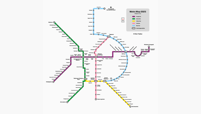
The operational network of Namma Metro primarily consists of two lines: the Purple Line and the Green Line. The Purple Line runs from east to west, connecting key areas like Whitefield, MG Road, Majestic, and Mysore Road. The Green Line travels from north to south, linking Nagasandra with Silk Institute and passing through important hubs like Yeshwanthpur and Lalbagh. The central interchange station at Nadaprabhu Kempegowda Station (Majestic) allows for easy transfers between these two lines, forming the backbone of the city’s public transport system.Future Expansions: A Growing Network
The Bangalore metro network is constantly expanding. Several new lines are under construction or in the planning stages, promising even greater connectivity in the near future. These include the Yellow Line, Pink Line, Blue Line (connecting to the airport), and Orange Line. Keeping an eye on the updated Bangalore metro map will reveal new travel possibilities as these lines become operational, with the network expected to cover 175 km by 2026. The expansion aims to connect more suburbs and major IT corridors, further solidifying the metro’s role in the city’s transport infrastructure.Tips for Using the Metro
Navigating the metro is straightforward. Stations are clean, well-marked, and feature maps to help you plan your journey. You can purchase single-journey tokens or get a smart card for easier and slightly cheaper travel. Trains generally run from early morning until late at night, with a frequency of about 5 to 15 minutes. Many metro stations also offer parking facilities and have feeder bus services to connect you to nearby areas, making it a truly integrated transport solution.Heritage Map of Bangalore: A Walk Through Time

The Foundation: Forts and Petes
A heritage journey should begin where the city did. Your map will guide you to the remnants of the Bangalore Fort, originally a mud fort built by the city’s founder, Kempe Gowda I, in 1537 and later fortified with stone by Haider Ali. Nearby are the historic ‘pete’ areas, like Chickpet and Dodda Pete, which were the original market hubs of the city. A walk through these bustling, narrow lanes offers a vivid glimpse into old Bangalore’s commercial and cultural life.Colonial Grandeur
The British influence is deeply etched into Bangalore’s urban landscape, especially in the Cantonment area. A heritage map will highlight magnificent colonial-era buildings. Look for Attara Kacheri, the stunning red-brick building that houses the High Court, and Seshadri Iyer Memorial Hall, home to the State Central Library. Churches like St. Mark’s Cathedral and St. Mary’s Basilica are other beautiful examples of colonial architecture that tell the story of a different era.Ancient Temples and Sacred Sites
Bangalore is also home to ancient temples that have stood for centuries. A heritage map should feature the Bull Temple (Dodda Basavana Gudi) in Basavanagudi, which houses a massive monolithic statue of Nandi. Another significant site is the Gavi Gangadhareshwara Temple, a cave temple known for its unique astronomical significance. The Halasuru Someshwara Temple, dating back to the Chola period, is considered the oldest temple in the city and a testament to its deep-rooted spiritual heritage.Culinary & Shopping Map of Bangalore: A Feast for the Senses
A Gastronomic Journey Through Food Streets
Bangalore’s street food scene is a vibrant and delicious affair. Your culinary map must feature VV Puram Food Street (Thindi Beedi), an iconic destination that comes alive in the evenings, offering everything from savory dosas and chaats to sweet jalebis. For non-vegetarian lovers, the streets of Shivajinagar and Mosque Road in Frazer Town are a paradise, especially during Ramadan, offering succulent kebabs, biryanis, and more. Exploring these food streets is not just about eating; it’s about experiencing the city’s lively street culture.Iconic Eateries and Local Flavors
Beyond the streets, Bangalore has a host of legendary restaurants. Your map should pinpoint institutions like Mavalli Tiffin Rooms (MTR) and Vidyarthi Bhavan for an authentic South Indian breakfast experience. These places have been serving generations of Bangaloreans and are a cherished part of the city’s culinary heritage. From the perfect masala dosa to aromatic filter coffee, these eateries offer a taste of tradition that is simply unmissable.From Traditional Markets to Modern Malls
The shopping experience in Bangalore is incredibly diverse. A comprehensive map will guide you through this retail landscape. For a traditional shopping spree, head to Commercial Street, a bustling hub for clothes, accessories, and great bargains. The nearby Chickpet Market is famous for its silk sarees and textiles. For a more modern and upscale experience, your map should direct you to malls like Phoenix Marketcity and Orion Mall, which house a wide range of international and domestic brands. Whether you prefer haggling in a crowded market or browsing in a chic boutique, Bangalore has a shopping destination for you.Conclusion
Frequently Asked Questions (FAQ)
What is the best type of Bangalore map for a tourist?
For a tourist, a dedicated Tourist Map of Bangalore is the best choice. It highlights major attractions like Bangalore Palace, Lalbagh, and Cubbon Park, helping you plan your sightseeing itinerary efficiently.How can a map help with Bangalore’s traffic?
A digital street map with real-time updates, such as Google Maps, is invaluable for navigating Bangalore’s traffic. It can suggest the fastest routes, predict travel times, and alert you to congestion, helping you save time and avoid frustration.Is the Bangalore metro map easy to understand for new users?
Yes, the Bangalore metro map is very user-friendly. It uses a color-coded system for its lines (currently Purple and Green) and clearly marks all stations and the main interchange at Majestic, making it easy to navigate even for first-time users.Where can I find a heritage map of Bangalore?
While physical heritage maps might be available at tourist offices, many online resources and tour companies offer curated heritage walk maps. These guides focus on historical areas like the Bangalore Fort, colonial buildings, and ancient temples.Can I find a map that shows both food and shopping areas?
A comprehensive travel guide or a specialized online map can serve as a culinary and shopping guide. It would pinpoint famous food streets like VV Puram, iconic restaurants, and major shopping districts like Commercial Street and Brigade Road.What are the main lines on the Namma Metro map?
The two primary operational lines are the Purple Line, running east-west, and the Green Line, running north-south. They intersect at the Nadaprabhu Kempegowda Station (Majestic), allowing for easy transfers across the city. Are there any new lines being added to the Bangalore metro map?Yes, the Namma Metro is undergoing significant expansion under Phase 2 and Phase 3. Upcoming lines include the Yellow Line, Pink Line, and Blue Line, which will connect to the Kempegowda International Airport.
Anita Rohilla
Anita Rohilla is a 28-year-old travel enthusiast and product tester with 5 years of experience reviewing travel gear and services. From backpacks to booking platforms, she tests and reviews each product to provide practical insights for travelers.

AI Assistant
Our AI writing assistant supports the creation of travel content under strict human supervision. All AI-generated posts are thoroughly reviewed, fact-checked, and updated by our team to maintain trust and accuracy in our travel recommendations.

Hotels in Bangalore: Your Ultimate Guide to the Best Stays
Searching for good hotels in Bangalore? Whether you’re visiting the city for work or leisure, there’s a wide variety of stays available—from luxury to budget
Places to Visit in Bangalore – A Complete Travel Guide
Bangalore, often referred to as the “Garden City of India,” offers a unique mix of nature, history, and modern attractions. Whether you’re a nature lover,
“Best Cafes in Bangalore – Top 5 You Must Visit”
Welcome to the Garden City, a place where the aroma of freshly brewed coffee is always in the air. Bangalore, a bustling hub of technology


