Navigating the Lifeline: Your Guide to the Mumbai Local Train Map

The Western Line: The Coastal Corridor
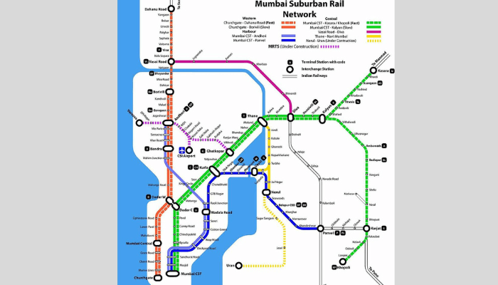
The Western Line is a vital artery for Mumbai. It runs parallel to the city’s west coast. It stretches from Churchgate in South Mumbai. It goes northwards to Dahanu Road. This covers a distance of about 123 kilometers. This line connects prominent residential areas. It also connects commercial zones. These include Dadar, Bandra, Andheri, and Borivali. The Western Line offers tourists easy access. Popular spots include Marine Drive and Juhu Beach. Bandstand in Bandra is also accessible. Dadar is a major interchange station. Passengers can switch between Western and Central Lines.The Central Line: The Heart of the Network
The Central Line originates from a historic place. It starts at Chhatrapati Shivaji Maharaj Terminus (CSMT). This is a UNESCO World Heritage Site. The line extends to northeastern parts of Mumbai. It is one of the busiest lines. It serves a massive number of commuters daily. The main corridor runs from CSMT to Kalyan. There, it splits into two routes. One heads towards Kasara. The other goes towards Khopoli. This line connects central suburbs to the city. It is vital for towns like Thane and Kalyan. Important stations include Dadar, Kurla, and Thane.The Harbour Line: Connecting the East and Beyond
The Harbour Line also starts from CSMT. It serves the eastern parts of Mumbai. It also connects to Navi Mumbai. It branches off at Wadala Road. One line goes towards Andheri on the Western Line. The other heads to Panvel in Navi Mumbai. This line has slightly slower train services. All trains on this line are ‘slow’ locals. They stop at every station. It is a critical link for commuters. It connects areas like Chembur and Vashi. The line’s expansion into Navi Mumbai was key. It helped develop this satellite city.The Modern Connection: Integrating with the Mumbai Metro Map
The expanding mumbai metro map integrates with the local trains. It offers a modern, air-conditioned alternative. Several metro lines now provide interchange facilities. For example, Metro Line 1 connects with the Western Line at Andheri. It also links to the Central Line at Ghatkopar. Newer lines like Metro Line 2A add more connections. This integration is a game-changer for public transport. It allows for hybrid journeys. Commuters can combine the reach of local trains with metro comfort. This synergy will enhance connectivity across the city. Travelers should consider a few tips. Avoid peak hours if possible. Trains can be extremely crowded then. Ticket purchasing is easier now. Use the UTS mobile app for digital tickets. This helps avoid long queues at stations. For tourists, a Tourist Pass is convenient. It offers unlimited travel for several days. Finally, always be mindful of your belongings. Be prepared for the fast-paced environment. A copy of the mumbai local train map is a must.Hitting the Streets: Mastering the Mumbai Road Map

The Major Arteries: Express Highways
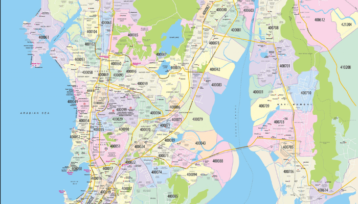
Two major highways dominate Mumbai’s road network. They are the Western Express Highway (WEH) and Eastern Express Highway (EEH). The Western Express Highway is an 8-10 lane highway. It stretches over 25 kilometers from Bandra. It connects to National Highway 48. It’s a critical link for the western suburbs. It also provides airport access. The Eastern Express Highway runs from Sion to Thane. It serves the central and eastern suburbs. To improve east-west connectivity, there are link roads. These connect the WEH and EEH at various points.Navigational Game-Changers: Freeways and Sea Links
Mumbai has modern engineering marvels. They help bypass traffic signals and congestion. The Bandra-Worli Sea Link is a prime example. It is a cable-stayed bridge. It reduces travel time between Bandra and Worli. It’s also a prominent landmark. It offers stunning views of the coastline. The Eastern Freeway is another key addition. It’s a high-speed, signal-free corridor. It connects Chembur to South Mumbai directly. These are toll roads. But they are worth the cost for the time saved. They are essential features on any modern mumbai road map.Navigating with Public Road Transport
Mumbai has many road-based public transport options. The iconic black-and-yellow taxis are common. They are mostly in South Mumbai. Auto-rickshaws are not permitted there. These taxis must use a meter. This ensures fair pricing. In the suburbs, auto-rickshaws are popular. They are great for short-distance travel. They are also legally bound to use the meter. Ride-hailing services like Uber and Ola are available. They offer app-based booking and cashless payments. BEST operates a vast network of buses. This includes double-decker and AC buses. They cover almost every corner of the city. Using apps like Chalo can help track buses in real-time.Tips for Road Travel in Mumbai
Traveling by road in Mumbai requires a strategy. First, avoiding peak hours is the golden rule. If you must travel then, allow extra time. Second, always use a navigation app. This provides live traffic updates. Third, insist on using the meter in taxis. This helps you avoid being overcharged. For long distances, the Sea Link can be a wise choice. It is useful between western suburbs and South Mumbai. Lastly, be prepared for a chaotic driving environment. Defensive driving is very important. Be aware of pedestrians and two-wheelers. A good map and these tips make journeys manageable.Discovering the City of Dreams: The Ultimate Mumbai Tourist Map

South Mumbai: The Heritage Precinct
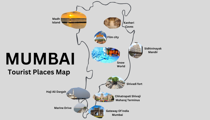
South Mumbai is the city’s historic heart. It is a treasure trove of architecture and culture. A mumbai tourist map here is essential. The journey often starts at the Gateway of India. It’s an iconic arch from the early 20th century. Opposite is the magnificent Taj Mahal Palace hotel. From the Gateway, take a ferry. Visit the Elephanta Caves, a UNESCO World Heritage site. A short walk leads to Colaba Causeway. This is a bustling street famous for shopping. Other must-visits are in South Mumbai. See the Chhatrapati Shivaji Maharaj Vastu Sangrahalaya. Visit the Jehangir Art Gallery. Don’t forget a stroll along Marine Drive. It’s also known as the Queen’s Necklace.The Vibrant Suburbs: Bandra and Juhu
Moving north, the suburbs offer a different flavor. Bandra and Juhu have a contemporary vibe. Bandra is the “Queen of the Suburbs.” It is known for trendy cafes and street art. Linking Road has many fashion boutiques. Key attractions include the historic Bandra Fort. It offers stunning views of the Sea Link. The serene Mount Mary Church is also popular. The Bandstand Promenade is a favorite spot. Juhu is famous for its sprawling beach. It also has delicious street food at Juhu Chowpatty. The area has the famous Prithvi Theatre. The ISKCON temple is also located here.Spiritual and Natural Escapes
A good tourist map guides you to other places. These include spiritual and natural sites. Mumbai has several revered religious sites. In South Mumbai, visit the Haji Ali Dargah. It’s a beautiful mosque and tomb on an islet. The Siddhivinayak Temple is dedicated to Lord Ganesha. For nature, visit the Sanjay Gandhi National Park in Borivali. It’s a vast green space within the city. Here, you can explore the ancient Kanheri Caves. These are a complex of Buddhist monuments. The Hanging Gardens on Malabar Hill offer a peaceful retreat. They provide panoramic views of the city.Putting It All Together: An Integrated Approach
The best way to explore Mumbai is with an integrated approach. Combine information from all available maps. For instance, use the mumbai local train map. Travel from the suburbs to Churchgate station. Then explore South Mumbai’s heritage district. To get from South Mumbai to Bandra, take a fast local. Within Bandra, an auto-rickshaw is ideal. Use a road map app to guide you. The new mumbai metro map is also useful. It connects key areas like Andheri. By layering these maps, you create a flexible strategy. This allows you to see the best of Mumbai.Frequently Asked Questions (FAQs)
What is the best map to use for navigating Mumbai?
The best map depends on your travel mode. For public transport, the mumbai local train map is essential. The mumbai metro map is also key. For driving, a real-time app like Google Maps is best. It works as a dynamic mumbai road map. For sightseeing, a detailed mumbai tourist map is highly recommended.How can I use the Mumbai local train map effectively?
Identify the three main lines: Western, Central, and Harbour. Know your start and end stations. Check which line they are on. Note interchange stations like Dadar and Kurla. Use them to switch lines. Also, distinguish between fast and slow trains. This will save time on longer journeys.Is it difficult to travel by road in Mumbai?
Road travel can be tough due to heavy traffic. This is especially true during peak hours. However, using expressways can speed up travel. The Western and Eastern Express Highways are examples. Toll routes like the Bandra-Worli Sea Link also help. Using navigation apps for live traffic updates is crucial.What are the must-have features on a Mumbai tourist map?
A good tourist map should highlight key attractions. These include the Gateway of India and Marine Drive. It should also include cultural hubs like Bandra. Major markets should be on the map. It must show the nearest train or metro stations. An integrated map with transport options is ideal.How does the Mumbai Metro integrate with other forms of transport?
The Mumbai Metro is designed for integration. Many metro stations are near local train stations. Andheri and Ghatkopar are examples. They also connect to major bus depots. This allows for a multimodal commute. It combines the reach of local trains with metro comfort.Conclusion

Anita Rohilla
Anita Rohilla is a 28-year-old travel enthusiast and product tester with 5 years of experience reviewing travel gear and services. From backpacks to booking platforms, she tests and reviews each product to provide practical insights for travelers.

AI Assistant
Our AI writing assistant supports the creation of travel content under strict human supervision. All AI-generated posts are thoroughly reviewed, fact-checked, and updated by our team to maintain trust and accuracy in our travel recommendations.

“Best Cafes in Mumbai You Shouldn’t Miss”
Mumbai’s energy is electric. It’s a city that never truly sleeps, and fueling this constant buzz is a vibrant and ever-evolving cafe culture. From historic

Places to Visit in Mumbai: Your Complete Guide
Mumbai, the bustling financial capital of India, is a city that never sleeps. Known for its vibrant culture, stunning landmarks, and scenic coastal views, it

Discover the Best Hotels in Mumbai for an Unforgettable Stay
Finding the best hotels in Mumbai is easy once you know where to look. Whether you’re visiting for business, leisure, or a mix of both,


